
Altitude: 350 m a.s.l.
Area: 10 sq km
Distance from Imperia: 15 km
Inhabitants: in 1881: 618 - in 2017: 482
Patron Saint Day: September 21st - San Matteo
Information: Municipality phone 0183 90200
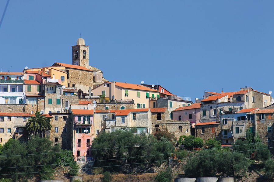
Return to the State Road and from the center of the town of San Lorenzo take the road that branches off to Lingueglietta, a fine example of a fortified village that was, already before the year one Thousand, "court" of the marquisate of Turin; in 1091 Anselmo de' Quadraginta took the title of Lord of Lengueglia (at that time that was the name of the village) giving life to the homonymous dynasty that for centuries dominated the area pushing its expansionist aims ever further away.
In 1341 the Lengueglias joined forces with Giorgio Del Carretto of Finale and attacked Albenga; but the Republic of Genoa, which was keeping an eye on the most enterprising local families, decided that it was time to stop the rise of these so lively Lengueglias and, in order "to protect the rights of the people", sent there its powerful army ready for war as a "peace force" to divide the contenders.
Poor Giorgio with his four bullies "... seeing this force of people coming at him, sent apologies to the Commander", but simple verbal excuses were certainly not enough for the commander of the Genoese expedition Simon Boccanegra who had something else in mind: he catched Giorgio Del Carretto and "... after placing him into a wooden cage, he had him put in the prison called Grimaldina. And Giorgio, seeing himself held in this manner, handed over to the commander his lands and the castles of several noblemen of Linguiglia who had conspired with him against Albenga”.
Without a shot being fired, Genoa thus gained control over the whole area which, ruled by dominated "allies", will remain ever since (1341) subjected.


Visit of the town
Once in the village, take the ramp that goes back to your left, arriving to the vast car park around the central summit where the few ruins of the thirteenth-century Lengueglia castle stand.
Climb the stairs to the left of the fountain and walk around the ruins going up the path until you reach the top: the three hundred and sixty degree view over the sea and valleys will reward you for the small inconvenience of the climb.
The thirteenth-century church of the Nativity of the Virgin Mary that you’ll face was repeatedly enlarged and raised, as the accurate restoration of the facade clearly illustrates; the portico supported by two stone columns was added in the late Middle Ages as well as the bell tower, later cut off and finished with the small dome.
The marble portal is instead of the seventeenth century (1621) as are the side chapels; on the little wall to the left of the church is a rustic ogival plaque of 1502 carved in the shape of a Maltese cross, clearly visible from the ramp below.
The interior, divided into three naves by the original four low stone columns, preserves in the vault above the side door sixteenth-century frescoes with scenes from the life of a saint; in the last altar on the left a glass urn installed in 1762 preserves the ampulla of blood and the remains of San Clemente, whose skeleton in a semi-lying position is covered with rich medieval clothes.
Next to the church stands the Baroque oratory of the Annunciation, whose monolithic architrave, there transferred from the rubble of the nearby castle, is carved with an archaic medieval crucifix between two abraded heraldic shields.
Go around the oratory on its left side, take the concrete stairway to the left and go under the archivolt in front of you continuing along Via Marconi, then turn right; you’ll thus reach the widening that dominates the valley where, isolated on the hill on the right, stands the Romanesque church of Sant'Antonio, which you will later visit.
On the left is the vault with stone benches of the Municipal Loggia of the village with the local Banco della Ragione; affixed to the left were the three stone basins that were capacity units for oil, wheat and wine, of which only the first one is still in fair condition, while on the opposite wall is affixed the "canna" (i.e. the “cane”), unit of measure of length; from the vault hangs the wrought-iron hook that held the lamp.
After passing the archivolt, turn right reaching fifty meters after the most significant example of a fortified church of western Liguria.
The thirteenth-century church of San Pietro, a typical Romanesque-Gothic building, was transformed into a fortress against the "Turks" at the beginning of the sixteenth century with the restructuring of the entire upper part, which replaced with rough masonry the original well-squared ashlars, preserved only in the lower part.
The construction was equipped at the top with a walkway all along the perimeter, fortified with the two hanging watch towers at the front left and rear right corners and with the slits that open in the small bell tower; the defense was completed by the perfectly preserved machicolation on five shelves that protects the entrance gate, and by the one on three shelves on the left side.
Of the original church thus remain only the lower part in squared stones with the splayed portal, the shelves and the oculus on the façade, the apse with hanging arches and the three monolithic-arch splayed single windows; the door on the right side has been walled up.
The interior, partly visible from the crack in the door, is simple and bare, with a single nave with a barrel vault and the original floor made of sandstone slabs.
Go around the church on its right side and after descending the cobblestone stairway in front of the apse, go and look to the right, at number 16, at the two small carved plaques, one with a Trigram, and the other one in a half-moon with the elaborate initial "M" of Mohammed, to unite the symbols of two religions united for the rest only by the sea of blood of the massacres in their name consumed in over five hundred years on the opposite shores of the Mediterranean.
From there take on the left the concrete stairway which, on the right, past the ruins of a house of 1709 decorated in the attic with rough frescoes of female faces, leads you to the archivolt that concludes the village with a panoramic view up to the sea.
Returning back, continue straight on along Via Scuole Dolmetta, named after the local philanthropist who in the 16th century assigned all his possessions to the construction of the village school, as reminds the plaque on his birthplace (opposite number 6) transformed into a school building; from there take the right under the vault of Via Marconi going up the concrete stairway from which, turning left, you’ll return to the square, passing under the sundial on the left side of the oratory.
You can now visit the upstream hamlet, which is actually much less interesting; proceeding along the central Via San Rocco you’ll find at number 25 an affixed upside-down plaque with a heraldic shield, and then the small Baroque oratory of San Rocco of 1611, with a simple semi-circular stone staircase.
The town ends a little further on at the crossroads marked by the quadrangular aedicule dedicated to the same saint, surmounted by an onion-shaped spire; the north side (too exposed to the elements) is bare, and in the niches of the other sides there were statues of saints which have been removed, while carved in the marble at the edges the guardian wizards who still today block the evil spirits at the threshold of the village are well preserved.
Go back to the car and then stop on the way back after about a kilometer and a half to continue on foot, taking - at the road sign that announces the crossroads - the cement descent to the left that leads, in two hundred meters of path among the fields, to the ruins of the fourteenth-century church of San Sebastiano.
On your right, in the open air and in total countryside, remain part of the apse and the perimeter walls, supported by sturdy buttresses and two stone columns with beautiful capitals supporting three round arches. The capital of the first column has carved on the four sides respectively a Trigram, an ark, a cross with flowers, and floral motifs, while the second capital has the emblem of the Lengueglias, a rosette, a cross in a tondo with rays and a Trigram in a radial pattern; in front are the ruins of the bell tower.
Back to the car, go down a short stretch of the Provincial Road and take the detour that branches off to the right a hundred meters after the graveyard; passed after the steep climb the nucleus of modern houses, drive the three hundred meters of cobbled mule track that bring you near the ancient cemetery now abandoned where the church of Sant'Antonio rises, administratively in the Municipality of Costarainera but physically and spiritually much closer to Lingueglietta and therefore placed and described here.
Founded in the 12th century by the Benedictines, the church preserves the original Romanesque-Gothic structures that were repeatedly retouched until the seventeenth century.
On the gabled façade opens the ogival arched portal in large stone ashlars carved on the keystone with a rough Agnus, while the door on the left has a bare irregular monolith as an architrave; the low bell tower decorated with hanging arches, a single-light window and the coats of arms of the counts of Lengueglia is original only in its lower part: the spire was rebuilt in the seventeenth century.
The interior is clearly visible from the front gate: originally with a single nave covered with trusses, the building was later enlarged with the addition of the two side aisles with cross vaults, the one on the left supported by massive square pillars and the other one by low stone columns one of which, replaced by a pillar, ended up isolated in the churchyard to protect the building with its capital carved with a Trigram in the center and guardian wizards at the corners.
The central wall that delimits the space reserved to the catechumens was covered with sixteenth-century Spanish majolica tiles later removed; the part of the floor in stone slabs is original, as well as the massive monolithic octagonal baptismal font to the left of the entrance and the architrave in black stone carved with a fifteenth-century "Ecce Homo" on the inner door that leads to the bell tower.
Returning to the Provincial Road, continue to descend to the junction where you’ll turn right and arrive to Costarainera.